⛰️ 等高线:平地图上怎么画出高低⛰️ Contour Lines: How a Flat Map Shows Height
上一片用比例尺量出了路有多远。可 🌍 蓝色星球向导一抬头:青崖山那段路是要往上爬的。地图是一张平纸,山却是立着的——平面上怎么画出「高」?Last leaf used the scale bar to measure how long the trail is. Then 🌍 Blue Planet Guide looked up: the Greencliff trail goes up. A map is a flat sheet, a mountain stands tall — so how does flat paper show height?
第 1 步:把山一层层切开Step 1: Slice the mountain layer by layer
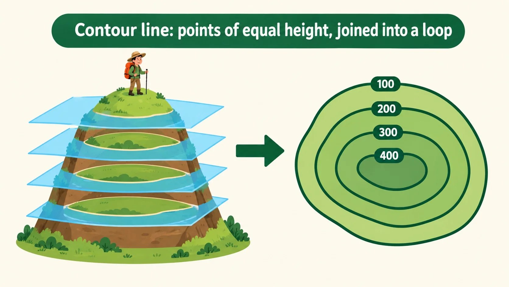
先看地图上那一圈圈褐色的线是怎么来的。First, where do those brown loops on the map come from?
想象海水慢慢淹没青崖山。水停在 100 米时,水边围出一圈;水再涨到 200 米,又围出一圈。把这些圈原样印到纸上,就是等高线。同一条线上,每个点都一样高——线上标的数字就是海拔。相邻两条线差多少米,叫等高距,青崖山这张图是 50 米。Imagine the sea slowly flooding Greencliff Hill. When the water stops at 100 m, the waterline forms a loop; let it rise to 200 m and it forms another. Print those loops onto paper and you have contour lines. Every point on one line is exactly the same height — and the number on it is that height. The gap in metres between neighbouring lines is the contour interval; on this map it is 50 m.
圈都画好了,可怎么一眼看出哪条路好走?The loops are drawn — but how do you spot the easy route at a glance?
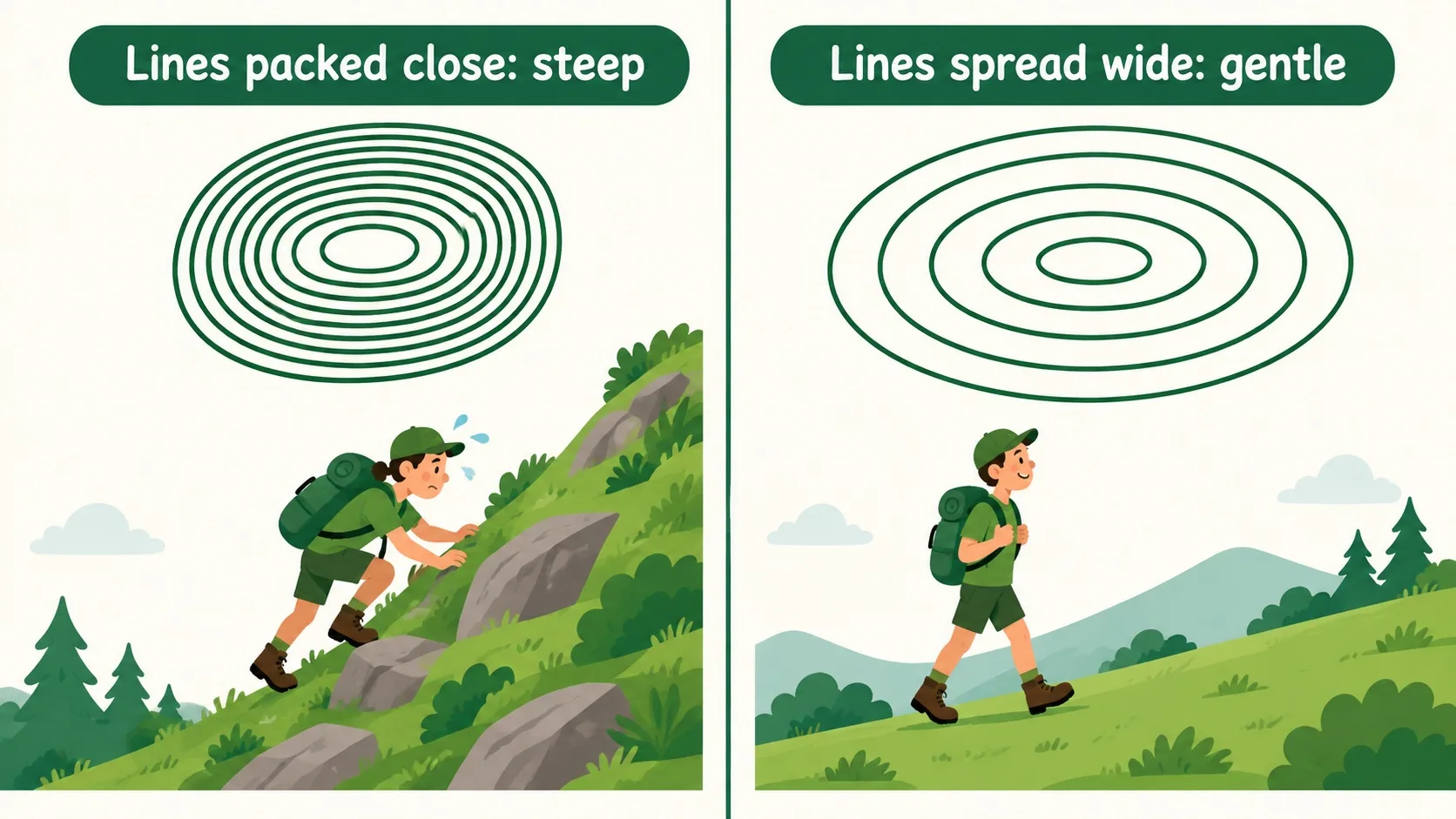
第 2 步:线挤就陡,线疏就缓Step 2: Packed lines are steep, spread lines are gentle
看两条线之间隔多远。同样上升 50 米,线挤在一起,说明这 50 米是在很短一段路里爬完的——那是陡坡,得手脚并用;线拉得很开,说明慢慢升,走起来轻松。青崖山东边的线挤成一把梳子,西边拉得很开,所以向导选了从西边上山:路长一点,但不用攀。Look at how far apart two lines sit. Both mean a 50 m climb — but if they are packed together, that 50 m is gained over a very short stretch, so the slope is steep and you will be using your hands. Spread far apart, the climb is slow and easy. Greencliff Hill's east side is packed like the teeth of a comb; the west side is wide open, so the guide picked the west route: longer, but no scrambling.
坡度会看了,可山上还有沟有梁,它们在图上长什么样?Slope, sorted. But a hill also has gullies and spurs — what do those look like on paper?
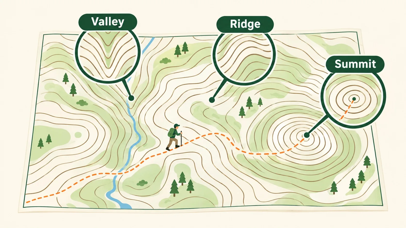
第 3 步:V 字朝高处是山谷,朝低处鼓是山脊Step 3: A V aiming uphill is a valley; a bulge aiming downhill is a ridge
等高线不光有疏密,还会拐弯。拐出的尖朝高处(数字大的那一边),那是山谷——下雨时水顺着它往下汇,走这儿常遇到溪流和湿滑的石头。朝低处鼓出去的,是山脊——雨水从两边分开流走,路面干、视野好,老徒步的人爱走山脊。一圈套一圈、越套越小,最里面那一小圈就是山顶。Contours also bend. Where the bend points uphill (toward the bigger numbers), you are looking at a valley — rain gathers and runs down it, so expect streams and slick rock. Where the lines bulge downhill instead, that is a ridge — rain splits and drains off both sides, so the ground stays dry and the view is open, which is why seasoned hikers follow ridges. And where loops nest tighter and tighter, the innermost one is the summit.
🎮 你来读这张图(30 秒)🎮 Your turn: read the map (30 seconds)
先拖水位,看等高线是怎么一圈圈长出来的;再接 4 道题,把陡缓、山谷、山脊都认出来。First drag the water level and watch the loops grow one by one; then take 4 questions and spot steep, gentle, valley and ridge yourself.
一句话记住它:等高线 = 把一样高的点连成的圈。线挤就陡、线疏就缓;弯尖朝高处是山谷,朝低处鼓是山脊。Remember it in one line: a contour line joins points of equal height into a loop. Packed lines mean steep, spread lines mean gentle; a bend aiming uphill is a valley, one bulging downhill is a ridge.
同一条等高线上处处一样高;相邻两条线的高差叫等高距(常见 10 米、50 米)Every point on one contour is the same height; the gap between neighbours is the contour interval (often 10 m or 50 m)线越密坡越陡,线越疏坡越缓;一圈套一圈,最里面那圈是山顶Packed lines mean a steep slope, spread lines a gentle one; nested loops shrink toward the summit弯尖朝高处 = 山谷(水往这儿汇);朝低处鼓 = 山脊(水从两边分开流)A bend aiming uphill is a valley (water gathers there); a bulge aiming downhill is a ridge (water splits off both sides)
内容参考 OpenStax 等公开教材,多来源核对 · AI 生成、人工审核 · 发现错误欢迎指正,帮这片叶子长得更好。Based on OpenStax and other open textbooks, cross-checked across sources · AI-generated, human-reviewed · Spotted a mistake? Tell us — help this leaf grow.
 Back to tree